Ramage Peak Trail

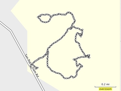
What better way to start out the new year than with a hike?  I had some new camera equipment to test out, and I wanted to find a nice canopy trail to photograph.  I checked my EBMud map and came across the Ramage Peak Trail, which starts at the Chabot staging area on Redwood Road, near Castro Valley.  

The trail marker at the start of the hike says you're on the Rocky Ridge Loop Trail, but the map says it's Ramage Peak Trail.  If you travel the whole loop, you'll hike 7.4 miles.  I just went in about 1 mile, and returned.  I just wanted to take some pictures, but kept going until the canopy opened up.  I'm saving the rest for another day...

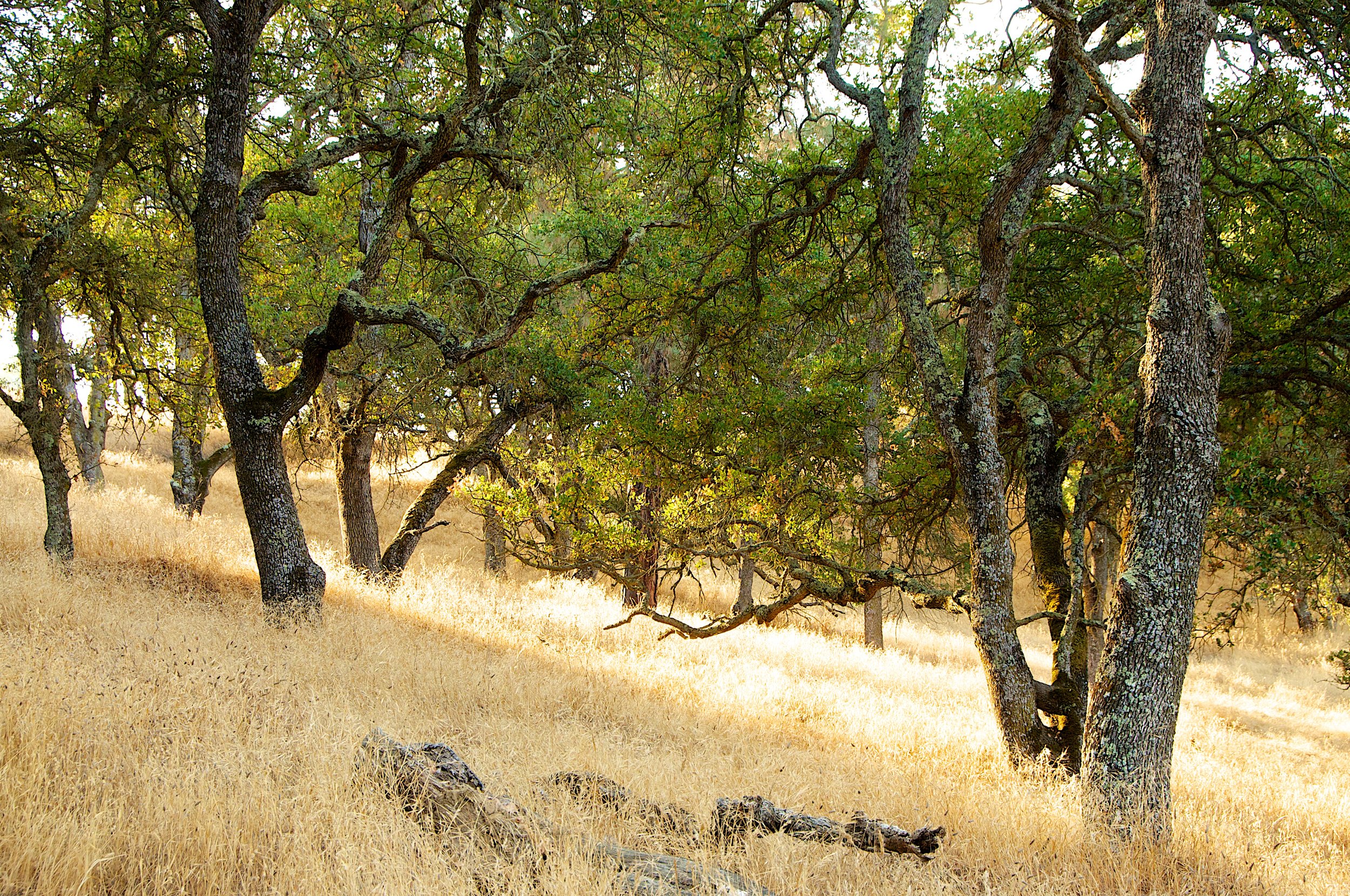
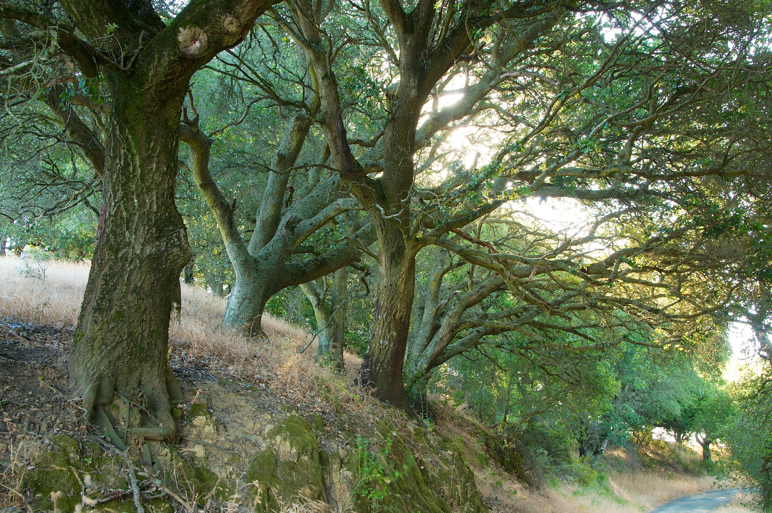
If you just want a nice and picturesque meditation walk, hike this short section of the Ramage Peak Trail.  Take your time, and enjoy the beautiful Oaks and Bay trees.  Start at the staging area, and catch the trail as it starts off on the right of the Christmas tree farm.  

Bathrooms are at the staging area.

Have Fun!

EBMud Trail Map

EBMud Trail permit


Ramage Peak Trail 1 1 13 18.jpg

Ramage Peak Trail

EB Mud Watershed

The Sea Foam Trails

Kennedy Grove Regional Recreation Area is a nice place to bring out of town visitors for a combination hike and picnic.  The picnic area is nestled under towering Eucalyptus trees, has a nice, clean bathroom, and a big area to romp around in.  Before you eat, you can take a hike on the Sea Foam trails, and see some beautiful Oaks and Bay trees.  

This is a small park with only a few trails.  My route started at the parking area.  I followed the Laurel Loop Trail to Lower Sea Foam Trail, then took the Upper Sea Foam Trail up the hill to the oak grove.  Take some time to enjoy the oaks.  The climb up is the only real strenuous part of this hike.  I followed the Upper Sea Foam Trail to the Kennedy Creek Trail.  You can take a left here, and go back to the picnic area.  Or, you can continue on and take the Black Oak Loop.  This short little loop takes you through even more beautiful and established Oaks.There is a picnic area in these Oaks too.  

Sea Foam Trail map.jpg

Path of the hike

Seafoam Trail 12_27_12 26.jpg

Seafoam Trails

Kennedy Grove Regional Recreation Area

Hike around Pine Canyon - Mt. Diablo State Park

It's been a long time since I've been to Mt. Diablo State Park.  It's one of my favorite places, but so are all of the other parks around here.  So, I got my trusty map and planned a hike.  I wanted to do a loop hike, and I found a nice route around Pine Canyon.  Most of this route is on fire roads, but Secret Trail is a single track that winds through some nice forest.  This was a busy route, filled with hikers and runners of all ages.  

The trailhead is located at the end of Green Valley Road in Alamo.  There is parking there, and bathrooms, but you'll need to pay the $6 fee in to a little box, and put your receipt on your dash.

Distance: 6.14 miles

Route:

Start out at the Marcedo Ranch Trailhead (End of Green Valley Road in Alamo)

Bathrooms, picnic tables, $6 parking fee

Take Wall Point Road

Bear Right at split between Dusty Road and Wall Point Road

Keep on Wall Point Road past Emmons Canyon Road

Climb to Wall Point at 1600 feet

Keep Left on Wall Point Road toward Secret Trail

Left on to Secret Trail

Left on BBQ Terrace Road

Left on to Stage Road 

Left on to Dusty Road

Right on Well Point Road back to parking lot

Notable Scenes:

Sun hitting the back side of these Oaks on the hill next to Wall Point Road

You'll see this nice cluster of Oaks as you climb Wall Point Road, just past the cow gate

Perching Scrub Jays on a Manzanita - Wall Point Road

Secret Trail - The only single track trail on this hike

Pine Canyon Mt. Diablo  258.jpg

Pine Canyon

Mount Diablo State Park

The Trails of Glendalough, Ireland

If your travels ever take you to Ireland, then journey up to Glendalough, in County Wicklow. There, you'll find the remains of a 6th century monastic settlement.  The lazy way to wander about is to take the Green Road trail, which passes the lower lake and touches the shoreline of the upper lake.  You'll pass through the old settlement and enjoy a leisurely stroll along the water.  

This is a history experience, along with a hike, and you'll get a true sense of the history of the place as you wander through the cemetery and around the lakes.  There is a visitor center with food and bathrooms. Numerous tours leave from Dublin, so visit Glendalough on your next trip there.  

The Round Tower. The opening is about 3.5 meters above the ground. The monks used to hide in here when threatened.

The main gate to the settlement. You can sense the history that walked through this gate.

Little Irish cottage by the Upper Lake.

Well maintained trails here.

Much of the walk is through beautiful Irish forest

A rare sunny day exposes more of the forest.

Wikipedia Entry

Wicklow Mountains National Park

Trail Map

Glendalough Ireland May 2012 070.jpg

Ancient Stones

Glendalough, Ireland


Hike to Briones Peak

Summer hikes in the East Bay can be challenging if you hike mid-day. Even the birds grow quiet, preferring to hang in the shade and watch weary hikers walk on by.  One way to avoid the fatigue and dust of a hike in the heat is to start out early.  It's also a great way to observe the beautiful morning light. Dawn is when the birds start chattering, and you'll have an opportunity to see them hunting for their breakfast.  

The parking area at the Reliez Valley Station is small, so get there early enough to grab a spot. Start out on the Blue Oak Trail, just past the gate. 

The trail splits, but reconnects later.  I took the single track trail on the left to avoid any bikers.  

The early morning sun gave a golden glow to the hills and Oaks as I climbed up the Blue Oak Trail. 

The trail here opens to a wider fire road.  You'll have views of rolling hills and the local suburbia, and even though this trail gets busier during the day, at this time of the morning it was peaceful and quiet.  In the high grasses, I saw a family of Wild Turkeys, and they scattered as I moved past them.  

Self Portrait on the Blue Oak Trail:

At 1.26 miles - Take a Left on to Spengler Trail.  Spengler splits here, but keep left for this trip to Briones Peak.

1.57 miles - Right on to Table Top Trail - On your climb to Briones Peak

From Table Top Trail, you'll see expansive views of the Carquinez Strait, and the Benicia/Martinez Bridge. You'll see this view again at the top of Briones Peak. 

1.94 miles - Keep Right on to Briones Crest Trail to Briones Peak

2.14 miles - On your Right is an unmarked little path to Briones Peak.  Follow this path for a short bit to a fence. On the other side of the fence is a nice bench with a view of the Carquiniz Strait.  If you're up to it, climb over the bars, sit and have a nice meal/snack/beverage.

Path to Briones Peak

View from Briones Peak

Return back down and head back the way you came.  At the Table Top/Briones Peak intersection, take a right on to Table Top Trail. This will take you on a nice, senic loop, but eventually leads back to the staging area.  Or, you could call it a day and return the way you came.  If you rested at Briones Peak, and had a snack, take the loop. It's great exercise.  

Scenes from the Loop:

Follow Table Top, and keep bearing left as you hike back.  This loop is going to take you back to the Table Top/Spengler split.   You'll follow Table Top on this loop, and eventually take a Left back on to Spengler.

At about 4.72 miles, you'll be back at the Table Top/Spengler split.  Continue Right on to Spengler.  Follow Spengler until you get back to the first split.

Take a Right here, on to Blue Oak Trail.  This will take you back to the Reliez Valley Staging Area.

HIke to Briones Peak 290.jpg

Hike to Briones Peak

Briones Regional Park