Tate, Toyon and Golden Spike

One morning, when the light was good for photography, I decided to find a local trail that I hadn't visited before.  The Golden Spike Trail was created in 1965, by a group of kids working with the Oakland Probation department.  There is a little monument to this on the trail.  

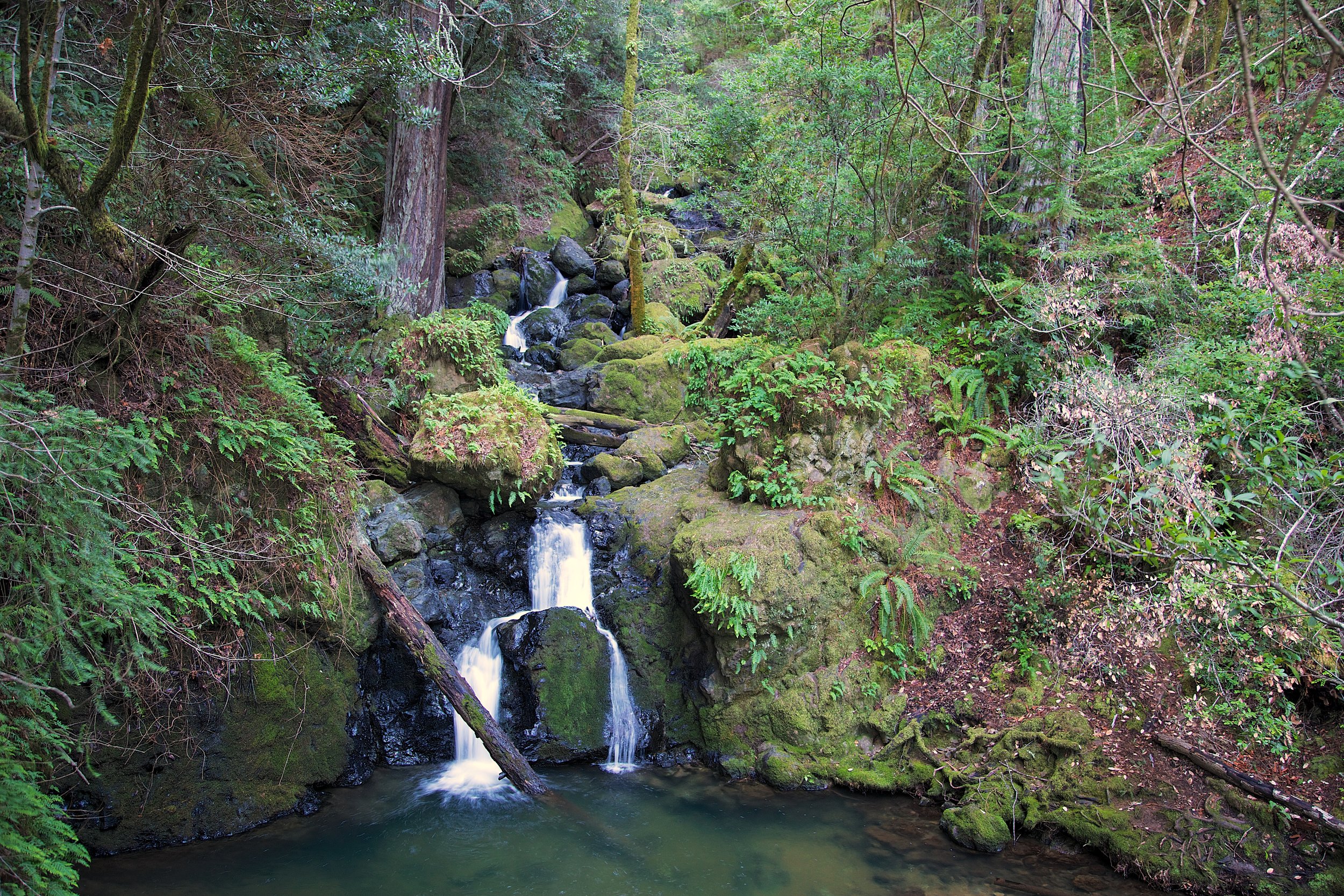
The trail is right next to a horse stable,  and there are a few signs of horses you might just want to avoid.  You'll smell the stables on parts of the Tate and Golden Spike trails.  In addition, Golden Spike is near Redwood road, so you'll occasionally hear cars zoom by.  However, there is a lot of beauty in this short hike.  Graceful Bays and twisted, ancient Oaks are all over these trails.  Nature can't paint a bad picture.  
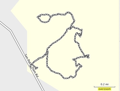
Route:

Start at the Big Bear Staging Area

Cross the street

Bear Left on to Golden Spike Trail

Right on to Toyon Trail

Left on to West Ridge Trail

Left on to Tate Trail

Left on to Golden Spike Trail

Bear Right on Golden Spike back to start

Mileage:

2.38 miles 

Golden Spike - Tate - Tonyon - West Ridge 1 24 13 90.jpg

Golden Spike

Redwood Regional Park


Cataract Trail to Laurel Dell

What a spectacular place!

This hike is located in the Marin Municipal Water District watershed, up near Fairfax.  The land is lush and vibrant, full of streams, waterfalls, a huge variety of trees, mosses and ferns.  You can soak up nature in this 3.02 mile (round trip) hike, and leave calm, refreshed and inspired.  

Take Bolinas Road in Fairfax to Mile Marker 8.13.  It's just past the narrow bridge you'll drive over.  Park on the side of the road.  Cataract Trail starts here.

Here is the Trail Map.

You'll see the Cataract Trail at the southwest part of the map, at the lower part of Alpine Lake. 

There are toilets and picnic tables in Laurel Dell, which is a great setting to rest, eat and contemplate.

Route:

From the trailhead, take Cataract Trail to Laurel Dell.  Hang out in Laurel Dell, then, take Cataract Trail back to the trailhead.  Total distance: 3.02 miles.  

Of course, use the map if you want to explore more of the watershed.  I definitely plan on going back. 

Here are a few scenes:

Lush trails next to the water

Waterfalls

Trail has stairs, but they are well maintained

Beautiful bridges and streams

Land of the Lost?

Lush and vibrant

This place has tremendous character...well worth a visit.


Cataract Trail 1 17 13 92.jpg

Cataract Trail

Marin Watershed

Big Bear and Bird Trails

Big Bear and Bird Trails are in the Anthony Chabot Regional Park, and I accessed them via the Big Bear Staging Area on Redwood Road.  

Big Bear is a .38 mile loop with a gentle climb.  It's got some nice canopy and a wide trail.  It's not much for exercising, but you can use it more as a place to wander and contemplate.

Bird Trail is a pretty but narrow trail, with wild raspberry bushes and poison oak reaching out to grab you as you hike through.  However, if you're careful, this short little trail (.34 miles) has some nice little bridges and meanders along a stream.  

Have fun and be safe!

Trail Map (Redwood Regional Park)

Trail Map (Anthony Cabot Regional Park)

bird2.jpg

Bird and Big Bear

Redwood Regional Park

Ramage Peak Trail

What better way to start out the new year than with a hike?  I had some new camera equipment to test out, and I wanted to find a nice canopy trail to photograph.  I checked my EBMud map and came across the Ramage Peak Trail, which starts at the Chabot staging area on Redwood Road, near Castro Valley.  

The trail marker at the start of the hike says you're on the Rocky Ridge Loop Trail, but the map says it's Ramage Peak Trail.  If you travel the whole loop, you'll hike 7.4 miles.  I just went in about 1 mile, and returned.  I just wanted to take some pictures, but kept going until the canopy opened up.  I'm saving the rest for another day...

If you just want a nice and picturesque meditation walk, hike this short section of the Ramage Peak Trail.  Take your time, and enjoy the beautiful Oaks and Bay trees.  Start at the staging area, and catch the trail as it starts off on the right of the Christmas tree farm.  

Bathrooms are at the staging area.

Have Fun!

EBMud Trail Map

EBMud Trail permit


Ramage Peak Trail 1 1 13 18.jpg

Ramage Peak Trail

EB Mud Watershed

The Sea Foam Trails

Kennedy Grove Regional Recreation Area is a nice place to bring out of town visitors for a combination hike and picnic.  The picnic area is nestled under towering Eucalyptus trees, has a nice, clean bathroom, and a big area to romp around in.  Before you eat, you can take a hike on the Sea Foam trails, and see some beautiful Oaks and Bay trees.  

This is a small park with only a few trails.  My route started at the parking area.  I followed the Laurel Loop Trail to Lower Sea Foam Trail, then took the Upper Sea Foam Trail up the hill to the oak grove.  Take some time to enjoy the oaks.  The climb up is the only real strenuous part of this hike.  I followed the Upper Sea Foam Trail to the Kennedy Creek Trail.  You can take a left here, and go back to the picnic area.  Or, you can continue on and take the Black Oak Loop.  This short little loop takes you through even more beautiful and established Oaks.There is a picnic area in these Oaks too.  

Sea Foam Trail map.jpg

Path of the hike

Seafoam Trail 12_27_12 26.jpg

Seafoam Trails

Kennedy Grove Regional Recreation Area