This hike is located in the Marin Municipal Water District watershed, up near Fairfax. The land is lush and vibrant, full of streams, waterfalls, a huge variety of trees, mosses and ferns. You can soak up nature in this 3.02 mile (round trip) hike, and leave calm, refreshed and inspired.
Take Bolinas Road in Fairfax to Mile Marker 8.13. It's just past the narrow bridge you'll drive over. Park on the side of the road. Cataract Trail starts here.
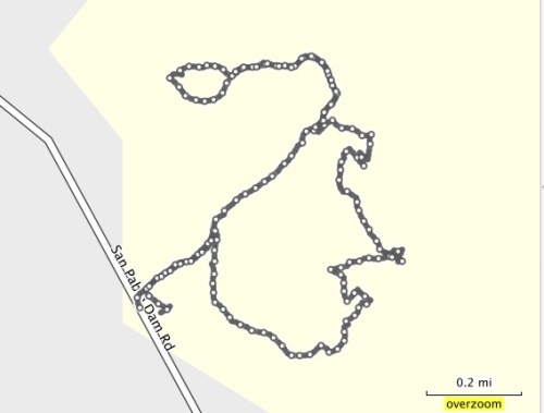
Here is the Trail Map. You'll see the Cataract Trail at the southwest part of the map, at the lower part of Alpine Lake.
There are toilets and picnic tables in Laurel Dell, which is a great setting to rest, eat and contemplate.
Route: From the trailhead, take Cataract Trail to Laurel Dell. Hang out in Laurel Dell, then, take Cataract Trail back to the trailhead. Total distance: 3.02 miles.
Of course, use the map if you want to expore more of the watershed. I definitely plan on going back.
Here are a few scenes:
Lush trails next to the water
Waterfalls
Trail has stairs, but they are well maintained
Beautiful bridges and streams
Land of the Lost?
Lush and vibrant
This place has tremendous character...very worth a visit!
Big Bear and Bird Trails are in the Anthony Chabot Regional Park, and I accessed them via the Big Bear Staging Area on Redwood Road.
Big Bear is a .38 mile loop with a gentle climb. It's got some nice canopy and a wide trail. It's not much for exercising, but you can use it more as a place to wander and contemplate.
Bird Trail is a pretty but narrow trail, with wild raspberry bushes and poison oak reaching out to grab you as you hike through. However, if you're careful, this short little trail (.34 miles) has some nice little bridges and meanders along a stream.
What better way to start out the new year than with a hike? I had some new camera equipment to test out, and I wanted to find a nice canopy trail to photograph. I checked my EBMud map and came across the Ramage Peak Trail, which starts at the Chabot staging area on Redwood Road, near Castro Valley.
The trail marker at the start of the hike says you're on the Rocky Ridge Loop Trail, but the map says it's Ramage Peak Trail. If you travel the whole loop, you'll hike 7.4 miles. I just went in about 1 mile, and returned. I just wanted to take some pictures, but kept going until the canopy opened up. I'm saving the rest for another day...
If you just want a nice and picturesque meditation walk, hike this short section of the Ramage Peak Trail. Take your time, and enjoy the beautiful Oaks and Bay trees. Start at the staging area, and catch the trail as it starts off on the right of the Christmas tree farm.
Kennedy Grove Regional Recreation Area is a nice place to bring visitors for a combination hike and picnic. The picnic area is nestled under towering Eucalyptus trees, has a nice, clean bathroom, and a big area to romp around in. Before you eat, you can take a hike on the Sea Foam trails, and see some beautiful Oaks and Bay trees.
This is a small park with only a few trails. My route started at the parking area. I followed the Laurel Loop Trail to Lower Sea Foam Trail, then took the Upper Sea Foam Trail up the hill to the oak grove. Take some time to enjoy the oaks. The climb up is the only real strenuous part of this hike. I followed the Upper Sea Foam Trail to the Kennedy Creek Trail. You can take a left here, and go back to the picnic area. Or, you can continue on and take the Black Oak Loop. This short little loop takes you through even more beautiful and established Oaks.There is a picnic area in these Oaks too.
Summer hikes in the East Bay can be challenging if you hike mid-day. Even the birds grow quiet, prefering to hang in the shade and watch weary hikers walk on by. One way to avoid the fatigue and dust of a hike in the heat is to start out early. It's also a great way to observe the beautiful morning light. Dawn is when the birds start chattering, and you'll have an opportunity to see them hunting for their breakfast.
This hike is a beautiful combination of rolling, oak studded hills, canopied trails and spectacular views. It starts at the Reliez Valley Staging Area, in Lafayette. (Just up the street, opposite, is the serene and welcoming Buddha Gate Monastery, well worth a visit.)
The parking area at the Reliez Valley Station is small, so get there early enough to grab a spot. Start out on the Blue Oak Trail, just past the gate.
The trail splits, but reconnects later. I took the single track trail on the left to avoid any bikers.
The early morning sun gave a golden glow to the hills and Oaks as I climbed up the Blue Oak Trail.
The trail here opens to a wider fire road. You'll have views of rolling hills and the local suburbia, and even though this trail gets busier during the day, at this time of the morning it was peaceful and quiet. In the high grasses, I saw a family of Wild Turkeys, and they scattered as I moved past them.
Self Portrait on the Blue Oak Trail:
At 1.26 miles - Take a Left on to Spengler Trail. Spengler splits here, but keep left for this trip to Briones Peak.
1.57 miles - Right on to Table Top Trail - On your climb to Briones Peak
From Table Top Trail, you'll see expansive views of the Carquinez Strait, and the Benicia/Martinez Bridge. You'll see this view again at the top of Briones Peak.
1.94 miles - Keep Right on to Briones Crest Trail to Briones Peak
2.14 miles - On your Right is an unmarked little path to Briones Peak. Follow this path for a short bit to a fence. On the other side of the fence is a nice bench with a view of the Carquiniz Strait. If you're up to it, climb over the bars, sit and have a nice meal/snack/beverage.
Path to Briones Peak
View from Briones Peak
Return back down and head back the way you came. At the Table Top/Briones Peak intersection, take a right on to Table Top Trail. This will take you on a nice, senic loop, but eventually leads back to the staging area. Or, you could call it a day and return the way you came. If you rested at Briones Peak, and had a snack, take the loop. It's great exercise.
Scenes from the Loop:
Follow Table Top, and keep bearing left as you hike back. This loop is going to take you back to the Table Top/Spengler split. You'll follow Table Top on this loop, and eventually take a Left back on to Spengler.
At about 4.72 miles, you'll be back at the Table Top/Spengler split. Continue Right on to Spengler. Follow Spengler until you get back to the first split.
Take a Right here, on to Blue Oak Trail. This will take you back to the Reliez Valley Staging Area.
Redwood Regional Park is one of my favorite places. Drop down in to the valley and the rest of the world seems so far away. In a normal winter, streams flow abundantly, and wandering through the trails here brings both peace and health. A few weeks ago, I visited the park from the Moon Gate Trailhead, and climbed to Redwood Peak. This hike offers a great variety of trails and terrain, so give it a try.
From the Moon Gate, head left on the West Ridge Trail.
Take a Right on to Tres Sendas Trail and descend in to the valley.
Nice mix of Bay and Redwood trees, with sword and forest fernsThe park is second growth Redwoods. The original inhabitants were used to build San Francisco
Take a Right on to Redwood Peak Trail.
Redwood Peak Trail is a bit rocky in spotsYou'll see some nice clusters of Bay Trees on the Redwood Peak TrailDon't miss the sign to reach Redwood Peak.
This is what you'll see on Redwood PeakOfficial marker at the top of Redwood Peak
Coming back down from Redwood Peak, you'll pass these sentries:
Take a Left on Madrone Trail
Nice Redwood cluster in Madrone Trail
Take a Left on French Trail
Take a Left on to Star Flower Trail
Take a Left on to Tres Sendas Trail
What a beautiful place to run!
Tread lightly, and avoid the roots
Left at the end of Tres Sendas to Moon Gate.
You'll have fun on this hike. It's beautiful and great exercise, and you'll have the satisfaction of scaling Redwood Peak (1539 feet).
Hiking to Las Trampas Peak is a nice, hill climbing workout. What's really nice is that when you reach the peak, you can enjoy a snack or lunch under a beautiful Oak and take in some spectacular views.
This is the Oak at the top of Las Trampas Peak. It's a beauty that will give you some nice shade and a place to contemplate.This park gets crowded, but crowded in a big park like this means you might see a few people on the trails. There are a few well traveled paths, and a number of the trails are equestrian friendly. I probably passed about 15 people, a trail record for me. It was nice to see so many people enjoying themselves on this beautiful day.
Take Hwy 680 to the Crow Canyon Road/San Ramon exit (in San Ramon) and travel west on Crow Canyon Road. Go Right on to Bollinger Canyon Road and go 4.5 miles to the very end of the road. There is a parking area on your left that gets filled early on beautiful weekend mornings. I got a spot, but people soon started parking on the dirt by the side of the road. There is a toilet there, but bring water.
Mileage: 4.5 miles
Route:
Chamise Trail
Left on to Las Trampas Ridge Trail
You'll pass through a gate to the last little climb to Las Trampas Peak
Backtrack to the Las Trampas Ridge Trail/Bollinger Creek Trail Split, and follow the Bollinger Creek trail back to the parking area.
From the parking area, walk back on Bollinger Canyon Road until you see this gate (about 500'):
I noticed a lot of cows on this adventure, so please close the gate. As you can see, this is the Chamise Trail, and this is where you'll start your hike. The first part here is a quick climb, so you'll quickly get your heart rate up as you climb this switchback. Looking back to your left as you climb, you'll see some nice views of rolling hills and the trails that start at the parking area.
You'll see signs for other trails, but stay on the Chamise Trail as it switches back through some thick shrubs that reach out to say hello.
I was passed by a couple of equestrians enjoying the climb, and it was a pretty sight.
There was a canyon to my right, with some interesting rock formations. Above the canyon, hawks were circling, and I could just imaging the same scene 500 years ago.
Soon, you'll be at the marker for the Las Trampas Ridge Trail. Take a left here, and you'll be on your way to Las Trampas Peak.
This image will give you an idea of how high you've climbed so far:
Las Trampas Ridge Trail takes you through some nice canopies. You'll see some Oaks, Bay Trees and a whole variety of twisty shrubs and grasses.
This Madrone cluster was spectacular.
The trail opens up, and you'll be enjoying nice views along the ridge line.
Eventually, you'll get to the sign for Las Trampas Peak, and it's a short climb from here to the top.
Take a break here to enjoy the views and rest. You deserve it, you just climbed to the summit of Las Trampas Peak, at 1827'.
After you enjoy yourself, turn around and backtrack down Las Trampas Ridge Trail to the split with Bollinger Creek Loop Trail, and bear right here.
Follow the Bollinger Creek Loop Trail past the cows and through the hills.
This last descent is a nice change from your uphill climb, so enjoy it. There isn't much shade along the way in this section, so protect yourself. On the descent, you'll pass another section of the Las Trampas Ridge Trail, but stay on the Bollinger Creek Loop Trail, bearing left, until you get to the parking area.
The Dublin Hills Regional Park is a pretty little hidden gem surrounded by highways and some new development. The trailhead/parking area is one of the more modern ones I've seen. It's easily accessible and has plenty of parking, so it's worth a visit.
The hills were unusually brown for this time of year, due to a lack of rain.
Location: To reach Dublin Hills: From I-680 southbound in San Ramon, take Exit 31, the San Ramon Valley Blvd. exit. Turn left on San Ramon Valley Blvd. San Ramon Valley Blvd. becomes San Ramon Road. Continue south to Dublin Blvd. and turn right (west). Continue west on Dublin Blvd. for two miles. The staging area is on the right. From I-680 northbound in Dublin, take exit 31, the Alcosta Blvd. exit. Turn left on Alcosta, and left again on San Ramon Road. Continue south to Dublin Blvd. and turn right (west). Continue west on Dublin Blvd. for two miles. The staging area is on the right. From I-580 eastbound or westbound, take exit 44A, the San Ramon Road/Foothil Road exit, and turn north on San Ramon Road/Foothill Road to Dublin Blvd. Turn west on Dublin Blvd. and drive for about two miles. The staging area is on the right.
Start out at the Donlon Point Staging Area. Lots of parking here, and bathrooms.
Most of this hike is exposed, with a little canopy area to rest under at about the half way point. However, you'll probably see some hawks hunting, and you'll certainly see cows. The trail is dotted with their reminders, so step carefully. You'll start out with a short (.13 miles) climb to the Caleveras Ridge Trail. Take a right at the top, on to the trail. As you climb, you'll see the development being built on your left.
There was construction going on during the hike, so this neighborhood is still being expanded. Keep right at marker 2, on to the Calaveras Ridge Trail. Keep left past markers 3 and 4. To your right is the short Donlon Point loop if you want to take it. Otherwise, follow the Calaveras Ridge Regional Trail to marker 5. On the Calaveras Ridge Trail, you'll have nice views of Dublin and Pleasanton across the valley.
The wind coming up from the valley was powerful, but it was wonderful watching the hawks ride this current.
At marker 5, take a right to the Donlon Loop Trail. You'll see the residents hanging out at the local watering hole, just chewing the cud.
At marker 6, you can go right or straight to complete this loop, I went straight. You'll soon come across another split. If you continue straight, you'll get on to the Martin Canyon Creek Trail, but go Right, on to the Donlon Loop Trail. This starts a nice little climb that will bring some air in to your lungs. The vista will open up as you climb, and you'll see more of Dublin and Pleasanton below you. At the top, you'll take a sharp right and descend on to a single track trail.
Go through a gate, and soon you'll descend in to a nice little canyon full of Bay trees and Oaks.
This is a nice place to rest in the shade and enjoy the beauty. There is a stream bed here, but it was bone dry, not good for this time of year. The trail crosses on to a residential street for a short detour, but it's well marked, and you'll have no problems reconnecting to the trail.
After you reconnect with the trail, you'll enjoy a little more canopy and foliage.
There is a little bit of a climb as you hike back to the start of the loop. The trail was heavily rutted here, so step carefully so you don't twist an ankle. When the ground is wet, the cows make deep impressions in the trail, and when it dries out, these impressions leave deep holes that are hazards for hikers and runners.
These hikers were enjoying the view from the Calaveras Ridge Trail.
Continue on the loop back to marker 6. Take a left there, and at marker 5, and continue back to the parking area.
Lake Temescal is a little jewel nestled right next to Highways 13 and 24. The park's 48 acres include trails that circle the lake. The East Shore and Dam Trails are paved, while the West Shore and Oak Bay Trails are dirt. As you'll see in the photos, the trails include live oaks, willow, laurel, thimbleberry, hazelnut, ferns, blackberry, toyon, a few redwoods, and of course, poison oak.
I started out on the Oak Bay Trail. It's a pretty trail that makes a gentle climb along the west side of the lake.
There is a nice variety of trees on this trail, including a few redwoods and a scattering of oaks.
You'll have some nice views of the lake from up here, and you'll also be able to see the Beach House (used for parties, weddings, etc.) highway 24, and the houses along the Oakland hills.
Oak Trail is a bit of a steep drop down to the paved Dam Trail. Along the north side of the lake, the paved Dam Trail is an access point from the north entrance of the park, and runs along a lawn area with a little playground and bathrooms.
Continuing on the Dam Trail, take a right on to the East Shore Trail. This trail takes you along the beach, past the beach house, the little waterfall and some nice trees, and gives you a level view of the lake.
Beach House
Little waterfall next to the Beach House
"Big Rock" under some twisted old oaks further along the East Shore Trail
At the end of the East Shore Trail, there is another nice little lawn area.
At this point on my hike, I doubled back on to the West Shore Trail. You may see quite a few fishermen on this trail, some carelessly smoking. But, I had some nice views of the lake along this dirt trail, and there were more than a few pretty trees hovering above the lake.
I came back on the same trail, and finished this short but picturesque hike. The total distance travelled was 1.72 miles. Not much of a hike, but run this a few times and you'll have a great workout. Enjoy!
I had a wonderful hike on Saturday that surprised me with beautiful canopies and spectacular views of Mt. Diablo poking out from an ocean of fog. Even though it was 36 degrees at the start of the hike, the nice ascent of the Sunrise Trail will bring out the heat in you.
Mt. Diablo rising up from the fog
Location:Briones Regional Park. Trailhead is at the end of Springhill Road, in Lafayette, Ca.
Starting at a secluded trailhead at the end of Springhill Road, you'll pass through the first of many cattle gates you'll encounter. You'll see the first trail marker, which will point the way to the Buckeye Ranch Trail. You'll shortly pass through another cattle gate, which will take you on the beautiful, canopied section of this trail. The sun was streaming in through the trees when I went, and the only sound was the occasional Jay squawking about my disturbing their morning.
Sun streaming in on the Buckeye Ranch Trail
This was a nice, peaceful forested trail, loaded with moss covered Oaks and Bay trees There was a dry creek bed to my right, but during a normal winter that should be flowing nicely.
You'll soon come to a Y split. To your right you can access the Sunrise Trail. But, keep to your left, as the Buckeye Ranch Trail will loop you back, and you'll want to enjoy a little more of this canopy. There are quite a few trees and groves with a lot of personality. Keep an eye out for this old giant that probably lived over 200 years before it collapsed:
As you loop back, you'll go through one more gate. Make sure you close all the gates completely, because there were a few cows lounging around in this area. At one mile, you'll see the sign for the Sunrise Trail. Go straight here, and soon you'll be wandering through this little cluster of oaks:
I came across the remains of a cow here, with signs that some nocturnal visitors had already started feasting on it. Sunrise Trail is a climb, and this is where you'll start to feel your quadriceps tingling and your heart knock on your ribs. You'll climb out of this little valley to follow a ridge line up along some rolling hills. Look at the photo map to get some perspective. On the morning of my hike the fog was heavy, and at this point I could see it still hanging around in the valley below me.
Keep climbing, keep climbing, you've got a ways to go. But as you climb, keep turning around to check out the view.
At 2.65 miles, you'll come to the Briones Crest Trail. Take this trail through some nice oaks, and enjoy the shade for a while. It's a nice spot for a PBJ and an iced tea.
It seems like I always make a few bovine friends on these hikes, and this crew was pretty cordial:
At 3.53 miles, you'll take a left on to the Lafayette Ridge Trail. The curves of this trail looked like a giant anaconda resting in the California sun.
At 3.66 miles, take a left on to the Buckeye Ranch Trail. Follow this trail through a few more scenic groves, and you'll come to the Sunrise/Buckeye Ranch Trail split. This time, take a right to the Buckeye Ranch Trail and follow that back to the trailhead.
Kennedy Grove is a beautiful surprise. I visited the park on a cold, wet November morning. Rainy skies usually provide the best light for photography, but it's tough to keep the camera dry. When I got there, it was just me and the ranger in the park. I was most interested in the trails around the recreation area, but it's a beautiful setting for picnics and gatherings.
Picnic area at Kennedy Grove
The Eucalyptus trees in this part of the park were planted in 1910. These trees grow fast, and as you can see above, they're huge.
It wasn't raining when I got there, but started as soon as I got my camera out. I pretty much had the place to myself, but I imagine this is bustling in the summer. Right off the parking lot, I got on to the Laurel Loop Trail. This is a wide trail, and it runs along the side of the lawn area.
You'll pass some of the Eucalyptus giants on this trail. I have mixed feelings about these trees. They are quite impressive, but they're non native and often poison the soil below them. The one plant that does seem to like them is poison oak, which is often found wrapped around the base of these trees.
After walking the Laurel Loop Trail, you'll see a sign that will guide you to the Lower Sea Foam Trail. By taking the Lower Sea Foam Trail, you'll be able to get some spectacular views of San Pablo Dam the the reservoir. At .70 you'll access the Lower Sea Foam Trail.
My GPS watch that tracks my elevation gains could not connect with a satellite, but the Lower Sea Foam Trail is a bit of a climb. I had the added weight of a few pounds of mud on my boots.
On this part of the hike, you'll go through mostly shrub, and the path becomes a single track trail.
As you hike, make sure you enjoy the views of the San Pablo Reservoir.
At 1.05 miles, I connected with the Upper Sea Foam Trail.
This continues your climb, but it is incredibly rewarding when you reach the top. The sight of a beautiful Oak grove took my breath away.
Take some time up here, and look at the incredible twists and contortions of these old trees. There are a couple of beauties with some real personality:
Follow the Upper Sea Foam Trail as it winds downhill through a dense army of Oaks that seem to reach out to you like green ghosts.
As you descend down the trail, you'll see more Bay trees, and the whole atmosphere, especially in the rain, reminds you of a scene from middle earth.
Follow the trail down to Kennedy Creek Trail, and take a left to head back to the picnic and parking area. There are still a few beautiful sights in this section.
You'll walk back to where you started, and you can tell your friends that they should have joined you on this hike. The total distance hiked was 2.28 miles, but be prepared for the climb to Upper Sea Foam Trail. Have fun, and be safe!
The Rocky Ridge trail has been on my "to do" list for a while. Certain parts are quite remote, but it offers beautiful views and a stunning grove of twisted and contorted Oaks.
There are a lot of cows in this hike. Starting out at Rancho Laguna Park, sign in at the station before the hike. Click on the Permit link to get a permit from East Bay Mud.
You'll hike up to see some peaceful rolling hills, usually dotted with cows. Follow the signs to the trail. At .40 miles you'll come to a split where King's Canyon Loop Trail and Rocky Ridge meet, so keep to your left and hike along the fence. You may see these trail sentries:
At .77 go through gate and get past this group of cows. You'll enter in to a beautiful grove of Oaks. In the winter, this next section has a nice stream through it. This area is particularly lush during the winter and spring.
At 1.14 miles, you'll leave this part of the forest and get on to a ridge trail. There will be some nice climbing in this area. You'll end up going through another cattle gate, and start a descent in to a valley.
At 1.84 miles, you'll see where the trail leads to your left, on to a fire road type trail. As you hike on this trail, you'll come to this sign:
It's confusing here. The sign looks like it's pointing to stay on the fire road, but it's actually indicating a trail off to the right. So stay to your right. Not knowing this, I enjoyed a little detour up this trail to a locked gate, then doubled back to this point.
I continued on this trail for just over 3 miles. At that point, I took out a few slices of pizza and an ice tea and watched the hawks circle lazily above me.
I returned back to Rancho Laguna via the same route.
Don't let the remoteness of this trail scare you away. It offers nice views, some great Oak forests and a wide variety of wildlife.
Shell Ridge Open Space is a widely used area, where you'll often see people with dogs, group hikers, trail runners and bikers. In the video below, you'll see that this area has a fair share of benches in nice locations, so you'll have a chance to rest and enjoy some great views. There are no trail maps located at the staging area, but you can find a map on the Walnut Creek Open Space page.
Location: Staging area is at the end of Sutherland Drive in Walnut Creek. Small parking lot, but no bathrooms or water.
Trails Featured: Fossil Hill Trail, Briones/Mt. Diablo Trail, Ginder Gap Loop Trail, Ridge Top Trail
Route: Start at the staging area at the end of Sutherland Drive. Follow Fossil Hill Trail to your right. Take a right on to Briones/Mt. Diablo Trail. At .97 miles, you'll see a sign that shows Coral Spring Trail and Briones/Mt. Diablo trail. Keep left here, and don't continue on the Briones/Mt. Diablo Trail to your right. The trail map has this trail listed as Ginder Gap Loop Trail, so it's a bit confusing. At least there was a guide to show me the way:
Soon, you'll take a left on to Ridge Trail (1.18 miles), which offers great views of Walnut Creek. When you look at the trail map, you'll notice that the Ridge Trail splits and reconnects a few times with some side trails. Take what you prefer, and when you get to the Water Tower, don't go down the road. Go past the tower and reconnect with the Ridge Trail on the other side (2.1 miles).
At the bottom of the ridge trail, take the Briones/Mt. Diablo Trail again. You'll follow that until you get to an unmarked split at 2.62 miles. Take the split to the right, which is the Fossil Hill Trail. You'll pass some big rocks, nice oaks and a comfortable bench under an Oak tree. Your hike is almost over, so break here if you want to. Keep on the Fossil Hill Trail until you get back to the staging area. Depending on which Ridge Trail splits you take, you're overall mileage may vary. Don't forget to print out the map before you get there.
This video follows the hike from start to finish, but read below for details.
Notes:
Round Valley Regional Preserve is a nice, secluded place with beautiful clusters of oaks and a wide variety of grasses, including rye, wild oats, foxtail chess, and wild barley. This was once home to California Indians, and evidence of their past activity has been found in several areas at the preserve.
I took a loop hike, which included only two trails, the Miwok and the Hardy Canyon Trail. Along the route you may see rabbits (Audubon or desert cottontail), hawks, golden eagles and certainly some ground squirrel, which are food for the raptors. In the rainy season, you'll see some nice streams and ponds, which are home to red-legged frogs, western toads, western pond turtles and Pacific tree frogs. You'll pass through oak woodland, with pockets of blue, valley, coast and interior live and black oaks. In my first visit, the buckeye was flowering, and the during the second visit, was dropping leaves. (The photos below show the flowering buckeye, the video will show their later stage.)
About the hike
Round Valley Regional Preserve feels like it's in the middle of nowhere, but it's well worth the trip. There is a nice parking area with toilets and an information/map board.
Start out on the Miwok trail and cross the bridge. You'll go through a cattle gate and start a rolling climb on a wide fire road type trail. On your left you'll see clusters of Oaks, and on your right, you'll see a pleasant vineyard. Be careful to avoid the horse poop and ruts on the trail left by cattle and horses.
You'll see some random trails shooting off Miwok, but I stayed on the main trail.
At .6, Cross a little cement bridge
At .72 Cross another cement bridge
At 1.14 Cross another Cement Bridge
At 1.28 Cross a heavier bridge
1.39 Stream on right is loaded with boulders. Seeing Oaks, boulders and grasses with patches of canopy
1.49 Take a Left on to Hardy Canyon Trail
Hardy Canyon Trail is a climb as you start up. To the right is a nice valley, to the left is an Oak studded hillside.
Hardy Canyon Trail is a narrow, single track trail. I saw squirrels and rabbits, and the valley below is beautiful...Hardy Canyon Trail will give you a nice, heart pounding climb. I saw a few runners coming down the trail, but I was the only one going up. This must be the hard direction!
2.35 on Hardy Canyon, almost all uphill, moderately steep
2.71 Trail here is in pretty bad shape, on right is a gulley, on left the dirt is rutted, but footing is precarious, but doable
2.97 Pond on right
3.25 Clusters of Buckeyes
3.83 Trail splits - take the trail to your left. The last time I was there, someone had blocked the trail on the right with a few logs. I think it goes past the ranch, but keep to the trail on your left.
Continue on through a few more forests of oak, and pass through another cattle gate.
4.66, cross back over the bridge to the parking area.
This is a nice out and back hike or run with limited elevation change and a beautiful canopy on most of the trail. There is a place to park just at the trail head, right off the intersection of Bear Creek Road and Camino Pablo. You'll see the trail, and you'll have to sign in and enter your EBMUD permit number and license plate number.
Starting out at the Orinda connector Trail, you'll see this:
At .22 Go straight on to the Orsan Trail. There are some beautiful old trees along the trail, with lots of bird activity. Also, much of the hike is along the San Pablo Reservoir, so you'll hear and see quite a few water birds.
At .57 Trail turns in to Old San Pablo Trail. On your right is an EBMUD maintenance site.
At 1.22 Cross the gravel road and continue
Nice Canopies throughout this hike
At 1.47 Cross Bridge
At 1.64 Old San Pablo Trail ends. At this point it turns in to Inspiration Trail. Turn around here.
On return, at 3.07, continue on to Orinda Connector Trail. Continue on until you're back to the start of your hike, at 3.31 miles.
Total Mileage: 3.31 miles (includes side trips toHidden Oaks Trail and Heavenly Ridge Trail).
Total Ascent/Descent: 1069 feet.
Notes:
Start out at the trailhead at the end of Coach Drive, a nice, quiet residential area.
Follow the gravel trail to your left. The paved trail to the right is to the water tower.
The initial Sobrante Ridge Trail starts out uphill on a wide, fire road trail. You'll see brush and the invasive French Broom plant on both sides.
You'll soon see a nice grove of Oaks on your right, off the trail. Pass the Morningside Trail on your right, and continue on the Sobrante Ridge Trail.
You'll soon see the Broken Oak Trail on your left. On your right is a picnic table, but continue on to the Broken Oak Trail. This is a very short side trail to a beautiful picnic setting under a grove of old and twisted Oaks. Sit here and enjoy the sounds of Hawks, Jays, Quail and other birds.
Climb back out via the Broken Oak Trail and continue on the Sobrante Ridge Trail. You'll pass another picnic table to your right, with some nice views.
Eventually, you'll see a sign for the Manzanita Trail on your right. Take this trail. You'll get to a point where the trail splits, and there is no sign. The trail on your right is the Heavenly Ridge Trail, which leads through a nice grove of Oaks, to another trail head and parking area.
If you don't want to see the Oaks, bear left on the Manzanita Trail. You'll soon see a trailpost and signage describing the Manzanitas. Take the short but spectacular Manzanita Loop. You'll pass wonderful old Oaks, and of course, the twisted and muscular Manzanitas. If you follow the loop starting counter clock wise, you'll go down hill a little. You'll have a nice view of a residential area, then climb back up a bit. In the last part of the trail, you'll hike under a little canopy of Manzanitas.
When you are pleasantly relaxed, continue back up the Manzanita Trail, take a left on the Sobrante Ridge Trail, and head back to the parking area.
Mileage: 5.3 miles, Total Ascent: 5152 feet, Total Descent: 5232 feet
Details: I thought we were going to have one of those storms that comes and goes quickly, but it rained throughout this hike, sometimes heavily. However, it was a great hike, with over 5000 feet of elevation change and wonderful scenery. I decided to try something new this time. I carried a video camera along with a still camera, and filmed the intersections where trails met. The video below is a combination of video and still images.
I started out by parking at the intersection of Canyon Road and Pinehurst Road. You can park just off the road there, or you can add .5 mile of trail by parking at the Valle Vista Staging Area and hiking from the start of Redwood Trail. This hike traverses on both East Bay Mud land and East Bay Parks land. So, you'll need an East Bay Mud trail pass, which you can get here. The first part of this hike is a serious but beautiful climb through Redwoods and Bay Trees. At the end of Redwood Trail, you'll find a gate in to Redwood Regional Park. Going through the gate takes you on to East Ridge Trail, a wide, fire road type trail. Take a Left on to East Ridge Trail You'll hike the East Ridge Trail until you get to Canyon Trail. Taking a right on to Canyon Trail takes you down in to the lush, Redwood heavy part of the park. Canyon Trail is downhill, and you'll end up at the Orchard parking area, which is loaded with picnic tables, barbques, bathrooms and a map stand. Keep to your right, and get on to the Stream Trail. This part of the Stream Trail takes you through some nice Redwoods, Bay Trees, and an assortment of play areas, shelters, bathrooms and picnic areas. This is a very tame part of the park, and part of Stream Trail is paved. If you plan your trip right, you should stop and eat your lunch or a snack here. Continuing on Stream Trail, you'll cross a bridge and come to the intersection of Stream Trail and Prince Trail. Take Prince Trail to the right, and it will lead you back up to East Ridge Trail. Take a right on East Ridge back to the original gate you came through, at Redwood Trail. Go through the gate again (Left here) and follow Redwood Trail back to where you started. This last bit of hiking is pleasurably downhill.
Video: This video follows the route, and incorporates some still images as well:
Images: While the rain made it difficult to take pictures, the light was nearly perfect, so I'm happy with the images I did get:
Huckleberry Botanic Preserve is a beautiful 240 acre gem tucked away in the East Bay hills of Oakland. The diversity of tree and plant life, the exotic sounds of numerous birds, and the twisted, narrow trails make this hike a treasured experience.
See the Photo Map here. (Oddly, several of the images were tagged to a residential area. Just a GPS hiccup.)
Trails Taken: Huckleberry Path, Skyline National Trail, Bay Area Ridge Trail.
Mileage: 1.7 miles for the self guided tour.
Trailhead: From Hwy 24 in Oakland, take the Fish Ranch Road exit just east of the Caldecott Tunnel. Continue .8 miles to Grizzly Peak Blvd. Turn left, and go 2.4 miles on Grizzly Peak to Skyline Blvd. Turn left and drive about 1/2 mile to the park entrance on the left, past Sibley Volcanic Preserve.
Huckleberry Preserve has a nice guided tour, if there are any of the brochures available. Several of the times I've visited, they were all gone, and some of the signposts had been knocked down. If you don't see any of the brochures, here is what you will find:
The parking lot at the trailhead is fairily small. There is a picnic table and a pit toilet. The trail starts on your right, where you'll find the maps and guides. You can take the upper or lower path, but the self guided tour starts on the lower path. At 1.7 miles, it's not a strenous hike, and I've seen numerous parents with young children on the trail. At Interpretive station 6, in the Manzanita barren, there is a nice bench where you can enjoy a break or lunch.
Taking the lower trail will lead you through a beautiful and lush Bay forest. Many of these trees are covered in a soft green moss, which seems to glow when hit by sunlight.
According to the brochure, there are flowering plants nearly year round. I spotted this beautiful lilac on the path:
Perhaps because of the abundant flowers, I could hear the buzz of Hummingbirds throughout the path. I was able to film one briefly:
You'll also see some spectacular spooky faces in the trees, like these:
This is an easy and beautiful hike, so get out there!
This is a nice hike, but the Eucalyptus Trees (Eucs) own this place. Expect to hear gunshots from the rifle range, and squeaks and moans from the Eucs as they welcome your presence.
Trails Taken - Starting out at the Marciel Gate, at 9999 Redwood Road, I took the Redtail Trail. Next, I took a right on the Deer Canyon Trail. I continued to the left on to Brandon Trail. (You can take Brandon Trail to the right for a more direct route to Stone Bridge). Next, I took a right on the Escondido Trail. That zigzaged along until I reconnected with the Brandon Trail. I kept to my left and followed the Brandon Trail to Stone Bridge. I ate some Trader Joe's Scotty Dogs at the bridge and turned around. I took the same trail back to where it split, and followed Cottontail Trail on my left back to the gate and parking lot.
Mileage- 4.53 miles, Total Ascent/Descent: 2953 feet
Trailhead - Moon Gate staging area, off Skyline Blvd. in Oakland.
Notes and Impressions -
It's an auditory experience hiking through this Eucalyptus Forest. You hear the snaps and cracks of branches falling, the moans of trees rubbing together, and the not so distant pop of gunshot at the rifle range.
Starting out on Red Tail Trail, I hear gunshots from the rifle range.
So far, fairly wide path.
.11 some Eucs on right, heavy brush, Oak, Pine, on left, a lot of shrubs, Spring is definitely popping here. New growth on a lot of the plants, loud, enthusiastic birds, scattered gun shots from the range.
.22 Walking on path along, but not right on the road.
.30 Path has little stream in middle, birds flying across, but no canopy, brush on both sides, poison oak, and I am walking along Mericel Road, which leads in to the rifle range and the campsites.
.35 Cross the Mericel Road to continue on to Red Tail Trail.
.40 Take a Right on Deer Canyon Trail.
.41 Forest of Eucs on Right, they are making a lot of noise as they rub against each other from the wind, lots of squeaks and haunting moans.
.44 Deer Trail is starting to descend, trail is really wet, and I'm in a Euc Forest.
.48 I can see San Francisco Bay from the top of this hill.
.54 Giant Euc has come down partially on the trail, but easily passable. This is all Euc here, they're giant, big old trees, some over 100' tall and very wide around the base.
.60 Taking left on to Brandon Trail from Deer Canyon Trail.
On Brandon Trail, I see some Oaks, but not too many. The Eucs are like an invading army here.
.66 There are some Oaks, Bay Trees, but mostly Eucs.
.73 On Brandon Trail, on hillside with wide fire lane road. Down to my right is a valley full of mostly Eucs, but some Oaks.
.86 This is a dense Euc Forest, I've never seem them this jam packed together, and they seem to be different types as well. They go straight up, so there is not a lot of canopy over the trail.
1.0 The rifle range is getting louder, storm is looking like it's going to hit me, so I have to pick up the pace. Just over 1 mile in, about 1.02, there is a little bench which has great vistas and overlooks the valley and the bay.
1.04 Taking a right on the Escondido Trail
Coming down the Escondido Trail, seeing more Eucs and hearing rifle range a bit more
I don't know what it is about Euc Forests, but they seem to be a bit haunted almost, maybe it's because they leave a lot of debris hanging off their branches, waving like ghosts, and the trees rub and grind against one another, making noises all along the trail. I think the Eucs are talking about me...
1.26 on Escondido, the trail is narrow, but the cleared space around it is wide enough for a car almost, full of grasses. Eucs and shrubs on the left of me, Euc Forest on the right. Birds fluttering around, I see some Towhees, Chickadees, and some Jays.
1.59 Just stumbled upon a flock of Wild Turkeys, but they moved away too fast for me to catch them with my camera. There are some boulders on the right of the trail, just past a dense Euc grove.
1.88 On Escondido, starting to see a few more Oak trees, but still quite a few Eucs. I just saw the Turkeys again.
Taking the descent on Escondido, as you wind around through these giant Eucs, I'm heading down to the valley floor, and I see some Bay trees, and a Redwood trying to break through the Eucs. Also, plenty of poison oak wrapping itself around the Eucs like protective sisters.
2.07 Now I'm in the Oaks, and there is a big boulder up a hill next to me. But, it looks like I'm about halfway down in to this valley on the Escondido Trail. Now I'm starting to go up just a bit.
Rifles at range are going off quite loudly in the distance.
2.22 Nice little valley to the left, where you'll see a nice Oak grove.
2.23, There is a little canopy.
2.45 I'm at intersection of Brandon Trail and Escondido Trail, and I'm going to take a left on the Brandon Trail, so I can take some pictures of the Stone Bridge
2.65 Some beautiful Oaks on my left here as I descend down this trail, really pretty Oaks, and a Madrone too. Oaks seemed to have held this spot from the Eucs.
2.94 Heading down Brandon .4/mile to see the Stone Bridge.
As I head to Stone Bridge, I'm seeing a few more Redwoods to my left, but still mostly Eucs.
3.22 More moaning Eucs.
3.35 On Stone Bridge, heavy, flowing stream below.
3.37 Heading back via Brandon to Cottontail Trail.
3.77 On Cottontail Trail heading to Maricel Gate.
3.83 Cottontail has my heart beating a bit, nice incline here.
This Cottontail Trail is a big slab of rock. I'm seeing RollyPollys wander across the trail, and Cottontails scattered on hill.
4.04 The Cottontail Trail is a powerful uphill. I'm taking a break to take some pics.
4.35 At top of Cottontail Trail, on my way to my car, still hearing guns at the range.
4.45 At end of hike, in parking lot at Maricel Gate. Picnic table here, but I don't see water or toilets.
4.35 At top of Cottontail Trail, on my way to my car, still hearing guns at the range.
4.45 At end of hike, in parking lot at Maricel Gate.
This is such a beautiful hike any time of year, but in the spring it really bursts with life and beauty. The streams are spectacular, and they form little waterfalls after a period of heavy rain.
Trails Taken - Starting out at the Moon gate, off Skyline blvd, I took the West Ridge Trail to the left. Not too far up the trail, I took a right on the Tres Sendas Trail. Next, I took a right on the French Trail, another right on the Redwood Peak trail, and a final right back on the West Ridge Trail back to the Moon gate.
Mileage- 2.34 miles (Heavy canopy) Total Ascent/Descent 4013 feet
Trailhead - Moon Gate staging area, off Skyline Blvd. in Oakland.
Notes and Impressions -
Starting out at Moon Gate
Took a left on West Ridge, Valley below, trail is muddy after a week of rain, but not too bad, houses on left, heading to Tres Sendas Trail.
Just getting started, .11, and there is a stream across the trail, and path is the width of a car
.14 Taking a Right on Tres Sendas Trail
Heading down Tres Sendas, and there is a stream going down it, following the curve of the trail
Sun is peeking out after a night of rain, but trail is muddy, and stream is loud and vibrant
Some Eucs on my left, some mossy Bay Trees on right
The middle of the trail is a stream, at .25, and on the right of the trail is the stream
.37 Trail is incredibly lush and bursting with life, trees are covered with moss, ferns everywhere, and the stream is raging
.41 Stream is going right down the side of the trail
.44 Steam is right next to the trail, trail is muddy with exposed roots and rocks, but beautiful in this weather
.48 Still on Tres Sendas, but stream dug out a gully in the trail, then it goes across the trail in to a larger stream on the left
.53 On Tres Sendas a giant Bay Tree has fallen across the trail, and I have to climb through it
.60 Taking a Right on French Trail from Tres Sendas
.59 Stream goes right across the French Trail, and there is a pretty little waterfall about 5 feet tall
Everything is rich and vibrant, ferns are lush and clean from the rains, streams are flowing like crazy, rocks are covered with moss, and I'm climbing up the French Trail
.69 On French Trail, crossing stream again
.76 Still on French Trail, left the stream area, nice soft path right through the Redwood Forest
.77 Away from stream now, I can hear some Jays squawking, don't hear stream as much anymore
.87 This part of the trail is a Redwood Forest, with lots of Bay Trees and Redwoods, very quiet and beautiful, everything looks green and lush from the rains
.97 This part of French Trail is a bit rocky, Bay Trees are covered in moss, lots of Redwoods
1.02 On French Trail, taking a right on to Redwood Peak Trail
1.04 On Redwood Peak Trail, there is a little bit of mist and fog, creating a stunning setting with ferns, moss and Redwoods
1.07 on Redwood Peak Trail, climbing up some steps of rock and root
1.12 As I climb Redwood Peak Trail, nice clusters of Bay Trees, and trees with red bark
Seems that a lot of Redwood Peak Trail is exposed rock and root, pretty technical trail, but the Bay Trees have that haunted forest look, they're twisted, clustered and covered in moss,and it's kind of dark, so it's a bit eerie in the fog
1.17 on Redwood Peak Trail, and the trail is very narrow here, lots of Bay Trees, seeing fewer Redwoods
Watching a couple of Chickadees taking a bath in a little puddle on the trail
1.33 Following the trail marker to the West Ridge Trail, at this point there are still Redwoods, Bay Trees
1.45 Taking a Right on West Ridge Trail
1.61 Just past the Redwood Bowl, and passed a class of kids out on a hike with Teachers and a Naturalist
1.78 Just crossing the road leading to Chabot Science Center
1.85 West Ridge Trail is right behind the Chabot Science Center, you can literally touch it
1.90 This part of West Ridge Trail is a bit noisy with cars from the road, seeing some Eucs, Bay Trees, Pines
1.97 This part of West Ridge Trail is partially exposed
2.05 West Ridge Trail crosses an road to the back parking lot of Chabot Science Center
2.07 Little grove of Eucs on left, somebody left their dog poop in a bag on the trail

 Lush trails next to the water
 Waterfalls
 Trail has stairs, but they are well maintained
 Beautiful bridges and streams
 Land of the Lost?
 Lush and vibrant
 This place has tremendous character...very worth a visit!