Trails Taken - This short hike starts at the intersection of Rim Trail and Rheem Trail. Take the Rheem Trail down to the valley floor. When you meet the intersection of the trail with the path to the reservoir, the trail turns in to Canyon Trail. Go straight on Canyon Trail to the other lip of Rim Trail. Return the same way.
Mileage- 2.2 miles round trip.
Trailhead - End of Campolindo Drive, no water, no toilets, limited parking in residential area.
Notes and Impressions - Just once back and forth on this trail is good exercise, but doing it twice is even better. There are steep climbs, especially on the Rheem Trail side. The valley floor tends to get wet in the spring. The trail itself can get muddy, but there are also a few streams that cross the path, and you'll need to jump them or go through them. Halfway across the valley you can connect with the .4 mile trail to the paved reservoir path. If you come down on the Rheem Trail, run to the reservoir and back, take the Canyon Trail to the other lip, come back down and repeat, you'll have a 3 mile route with some nice hill climbs. There are some beautifully shaped trees along the way, and the valley is home to quite a few noisy birds, especially scrub jays.
Trailhead - Valle Vista Staging area, portable toilet, no water
Notes and Impressions - This is a nice little loop for running or hiking with kids. I took my kids on this trail when they were younger. I often see little rabbits hop across the path as I walk or run. They quickly dive in to the thick brush to hide from the ever present hawks that circle overhead. Since this is next to the Upper San Leandro Reservoir, you'll have a chance to see and hear a nice variety of waterbirds. In the middle of this loop is a meadow that hosts trees, brush and is a sanctuary for all sorts of chirping and squaking creatures, and the creatures that prey on them. I took this picture on the Riche Loop back in November of 2007. He was just looking for dinner, and he left us quite alone.
Then, there is the mystery of the missing house. What you'll see from the trail are old, overgrown Indiana Jones kind of steps, leading to nothing. Who ever built these steps, and the house they led to, are long gone. All that's left is a conversation starter, especially with kids. Have fun on this trail.
Trails Taken - We started out on the trailhead at the end of Campolindo drive. We followed the trail north to the Reservoir. There are several side trails along the way, but we kept to the right. Eventually the trail drops down to the paved section of the Reservoir loop. Just before we dropped down, we came across a lost dog. After wandering around the dam area, we found the happy owners. After that, we forgot to access the Rim Trail on ramp at the other end of the parking lot, and walked right past it. So, we continued on to the Westview trail, and climbed back up on Rim. At the top, we took a left and followed the Rim Trail back to the start.
Mileage- 5.71 miles
Trailhead - 3849 Mt. Diablo Blvd. Lafayette, CA. This is the main parking area, with bathrooms and water.
Notes and Impressions -
The trail started out slightly wet in some places, and cracked in others. Much of the Rim Trail is exposed, so bring sun block and wear a hat.
Some trails offer switch backs to decrease the angle of ascent, but not the Rim Trail. Expect some heart pounding hills. You'll have great views of the Reservoir, see some canopies, and walk through some really pretty sections of the park area. At that point, there are bathrooms, water and picnic tables. It's a beautiful and popular area. Here is the EBMud Lafayette Reservoir page. Get there early for better parking.
This is a trail shared by runners, hikers and dogs, so step carefully.
There is a tremendous variety of wildlife in this area. I've seen deer, rabbits, numerous raptors and water birds. I almost always hear or see Wild Turkeys.
There are three trails that drop you to the reservoir from the Rim Trail. They are Big Oak Trail, Campolindo Trail, and Westview Trail. You can create numerous paved and dirt trail loops from the start at the parking lot, and each one would offer some nice hills to climb. Two other trails cross the valley from opposite sides of the Rim Trail. Canyon Trail is a gentler incline and takes you under a majestic old oak. Rheem Trail is steep and is challenging in both directions. This is 1.1 miles from side to side. About half way across is another trail that takes you to the reservoir.
Recorded notes:
.28 Little bit of a hill
.49 Totally exposed, brush on right, Oaks and Eucs on left, houses on right
.63 Serious horse deposit on trail
1.05 Beautiful view of reservoir, passing lots of people, runners/hikers/dog walkers
1.11 Lots of birds, especially Scrub Jays
1.2 On left is forest of Oaks and variety of trees in valley below, I can hear lots of birds down there
1.22 Seeing reservoir as you crest the hill
1.51 Really nice views of the reservoir from here, you can see people fishing and hanging out in play area, hills green
1.62 Heading down to reservoir
1.70 Passing beautiful twisted old Oak, nice valley, lots of bird activity
1.75 Jays really chattering today
(Paved section, dog rescue, lunch, siesta, etc)
3.23, Leaving paved reservoir, going to Westview Trail
3.32 Climbing up via Westview Trail, lots of twisted old Oaks here
3.51 Getting steep, no switchback, just up
3.90 Higher elevation, some pine trees and redwoods
R on Mott Peak Trail (Maud Whalen campsite is on your left)
R on Briones Crest (Look for Sindicich and Manicich Lagoons)
R on Old Briones Road Trail
L on Valley Trail
R on Yerba Buena Trail
R on Crescent Ridge Trail (Hike past Archery range)
R Seaborg Trail back to Trailhead (Keep to your left)
Mileage - 5.76 miles, Total Ascent 2431', total descent 2415'
Trailhead - Bear Creek staging area (EBRPD, not EBMUD) If you are coming from Orinda, the EBRPD Bear Creek staging area is on your right, just after the EBMUD Bear Creek staging area, on your left.
Notes and Impressions -
At the EBRPD Bear Creek trailhead, you'll find toilets and water and nice picnic areas. If the gate is attended, you'll have to pay a fee to enter.
.14 Starting on Old Briones road trail, sign on gate says watch for cattle and water line is broken...saw lots of horse poop
.31 Nice trail for dogs, passed a trail runner with dog, wide, beautiful tree lined trail
Steep hill on right, decline on left, trail is wide enough for car
.37 Valley on left is loud with birds
.44 Just passing beautiful old oak covered with moss, canyon on left and incline on right
.54 Little stream crossing road, you can see a lot of erosion on left from recent rain, where the side of the hill just caves in
.56 There is a nice bench to observe valley and hills across the way, Buckeyes getting leaves, nice Oaks
.64 Still on gravel trail, to left are hills with drop down to valley, hills full of birds, sun hitting that spot, some rock exposure in the hills across the way
.74 Trail is still wide fire road/gravel, to right is hillside, with terracettes, hawks hovering
.76 Crossing over a little stream
.79 So far it's been completely exposed, but nice views of valley to the left, Bay trees, Oak trees, to the right is grass
.90 Hear stream loudly on left
.94 At intersection of Mott peak and Abrigo Valley trail, big meadow and pit toilet, giant old oak here, must be hundreds of years old
.94 Starting on Mott Peak, to left is big lean-to structure
1.03 Crossing a little stream on the trail...starting to climb
1.11 Climbing up Mott Peak, water tower on right, huff huff...
1.14 Bear to left on Mott Peak trail
1.14 Trail is pretty wet and muddy in middle but dry on left, mostly exposed with brush and oak, occasional bird activity
1.22, Trail is really muddy here, stream almost going down the middle of it
1.25 It's like I'm walking through that clay we used to use in 3rd grade
1.28 Climbing on Mott Peak Trail, totally exposed rolling hills as I go through the muck...some sign of spring wild flowers, hawks circling above
1.34 Path that goes to right, but I'm staying to the left, trail marker ahead, hawk on the trail marker, but he disappears as I approach
1.40 At intersection of Mott peak trail and Black oak trail, I'm staying on Mott Peak to left
1.44 Lots of paw prints on the ground, probably dog, seeing lagoons down below
1.46 Going up hill, in area of rolling hills and seeing lagoon
1.55 Cattle country, on ridge, see rolling hills all around me, to my left in distance is San Pablo Bay
1.57 Far off I can hear a train (to left) seeing birds hunting
1.68 Numerous little trickles of water going across the trail, ATV tracks on road
1.73 Just went through gate, giant hawk on fence up ahead, beautiful views of mothball fleet in Suisun Bay, Benicia Bridge, see Martinez, Concord
1.77 At intersection of Briones Crest Trail and Mott Peak Trail, all is lush and wet, (Also called Ivan Dickson Memorial Loop Trail
Hiking down Briones Crest Trail, extremely muddy in spots
1.84 See some ground squirrels on left, some lagoons with lots of birds, ducks, etc
1.88 Little bench to eat lunch or take a break
Sitting on bench eating lunch, seeing refineries, mothball fleet, windmills off in distance, Mt. Diablo
Cow crew ahead checking me out
2.12 Sign explaining terracettes and seasonal ponds
2.18 Trail runner just passed me, now a biker, lots of trail activity, see some terracettes on hills
2.2 Full sun now, seeing more hikers, runners, bikers
2.39 At intersection of Briones Crest Trail and Old Briones Road, taking a right on Briones Crest Trail
2.51 Taking Old Briones Road to Valley Trail
2.53 Seeing lots of ground squirrels
2.56 Taking Valley Trail because sky is washed out today and I want some canopy shots
2.60 Trail is very wet, rutted, bikes, ATVs, cattle, people, horses, just a mess
2.71 Steep cliff on left and drop on right as I descend Old Briones Road
2.74 Heading down in to valley, beautiful trees coming up
2.81 Trail is crazy wet, just passed hiker and her dog, lots of dogs on trail today
2.87 As you come down there are nice rolling green hills on right, Buckeyes starting to bloom
2.90 Seeing fresh bike trails, I don't know how they got through this mud
2.95 Little stream flowing right on left edge of Old Briones road, but then goes under via pipe and blasts out on right
3.04 Cattle pen ahead, going to Valley Trail
3.18 Valley trail goes to left, taking that
3.33 Passing a bench on Valley Trail, on left are hills with terracettes, hawks circling, maybe a cave on the hillside? I'm on a rancher road, barb wire fence on right, maybe a stream bed on right (can't see), lots of birds about
3.50 Getting buzzed by giant bees, but they're not bothering me, just checking me out
3.56 Little lagoon, Great Blue Heron just took off
3.67, Taking right on Yerba Buena Trail to right, path is not too apparent, but you'll see the gate across the meadow
To get to Yerba Buena trail you need to cross the meadow and go through gate
Starting Yerba Buena trail, it's wet and there are bike tracks in the fresh mud, smelling a musty, forest scent
Early part of Yerba Buena, lot of Bay trees, very wet
3.96 On Yerba Buena to left is an steep incline, to right are nice Oaks and Bay trees and hillside
4.04 On left of Yerba Buena trail hillside is steep, and trees are showing their roots after erosion washed away soil
4.05 Remains of old gate on trail, part of fence post is embedded in tree
This part of Yerba Buena trail at mile 4.13, quite a few Bay trees, shrubs, Oaks, ferns, quite a variety of life, hawks flying over me
4.2 Yerba Buena trail starts going up hill
4.35 on Cresent Ridge, looking at valley below which is lush
4.4 beautiful oak groves on right, gnarled and twisted, really pretty
4.43 Heading down Crescent Ridge trail, little bit of downhill, heading to valley below, can see the archery range
Hearing frogs on right in the Oak forest
Somewhat steep descent coming down
4.79 Just passing Archery range, friendly cows hanging out
4.94 Taking right on Seaborg trail
4.95 On Seaborg trail, wide trail, dirt and gravel, on left is dense brush, on right is open meadow, hearing stream on left, seeing Manzanita bushes
5.16 Stream is down below, seeing small waterfall
Very steep side trail to waterfall, steep and slick
5.23 Walking this part of trail just a constant sound of stream on left
Mt. Diablo doesn't get snow every year, and it looks like this year we'll see it covered in snow from multiple storms. After last weeks hike to see the falls in Mt. Diablo State Park, we decided to visit again, and entered the park via the Mitchell Canyon staging area.
Trails Taken - From the trailhead, we took Oak Road to Mitchell Rock Trail. Then, we went right on Mitchell Rock trail and climbed to Twin Peaks, at 1733 feet. We descended a little and came to the Eagle Peak Trail split. We took the trail to the left, which descended down to Coulter Pine Trail. At this point, you could take the Coulter Pine Trail back to Oak Road and the Trailhead, but we continued on to Bruce Lee Road. We took a left on Murchio Road, and another left on Watertower Road. That connected us to Oak Road, which we took to the Trailhead.
Mileage - 4.1 miles, total ascent 1757'
Trailhead - South end of Mitchell Canyon Road in Clayton, California. Bathrooms and Interpretive Center located here as well. Entrance fee required.
Notes and Impressions - At the time of this hike, the trails were quite wet and muddy. In addtion, there is equestrian traffic on some of the main trails, so be careful for horse bombs.
I noticed quite a lot of bird activity on this hike, especially Jays. They seemed to be the lookouts on the trail, letting the other creatures know we were on our way. We saw some skittish rabbits and a load of raptors.
Often, the trails narrowed with heavy brush on both sides, and in some cases, overhead. Trail conditions ranged from rocky, to muddy, to steep.
As we climbed, the trails became narrow. You won't need ropes to pull yourself up, but you will feel it in your cheeks and legs.
That giant scar across the face of Zion Peak is explained on the MDIA website:
The diabase quarries on the northside of the mountain (Zion Peak) are currently being excavated for crushed rock and rip rap material.There were several excavations in graywacke on the northside of the mountain for the same purposes,but they are now abandoned. Blue schist from the Franciscan rocks on Mt. Diablo yielded good dimension stone and was popular for building construction due to its color.
Overall, a pleasant and moderatly difficult hike that offers great views and exercise.
This wonderful hike was organized by the Mt. Diablo Interpretive Association and led by Helene Crowley, and they offer hikes like this quite often. Please visit their events page to learn more.
Trails Taken - Regency Gate to Donner Canyon to Lower Donner to Wasserman, down Cardinet Oaks to the Falls Trail, Falls Trail to Middle Trail. Middle Trail to Meridian Ridge, Meridian Ridge to Meridian Point trail, Meridian Point to Back Creek, Back Creek to Regency Trail, back to Regency Gate.
Mileage - 6.5 miles
Trailhead - End of Regency Drive, Clayton, CA. No bathrooms or water.
Notes and Impressions - As you'll see from the images, this hike offers a variety of experiences and scenery. It's not an easy hike, and the trails can be narrow and steep, but it's enjoyable and satisfying and I'd highly recommend it.
This time of year (Spring, 2011) offers great opportunities to see mountain wildflowers, flowing streams and, of course, waterfalls. If you're expecting Hawaii type waterfalls, you'll be disappointed, but even with moderate water flowing, it's still beautiful. These falls are visible, but not accessible from the trails. You won't be walking under them. You'll also see numerous streams and the vibrant life they support. Much of the terrain around the trails is choked with heavy brush, some bursting with new life, and reaching on to the trail. Nothing is impassible though, but you'll need to be careful with your footing in many places. Loose rock, water and brush create obstacles that can be a little challenging.
Bear Creek is a pleasant and senic hike, with ample views of the reservoir as you hike along the shore.
Trails Taken - Bear Creek Trail
Mileage - 3.8 miles (One way)
Trailhead - Started at Bear Creek staging area, finished at Overlook staging area.
Notes and Impressions -
Started out in a little brush, but trail opened for a little, and I saw this unique tree right in the field to the left of the trail:
I hiked for approximately .56 miles, and reached the "real"start of the Bear Creek trail, which then follows along the reservoir for the rest of the hike.
The trail is mostly shaded and very pretty, and at about 1.05, there is a nice bench to relax upon.
1.17 In a wooded shaded area with lots of bay trees, brush, mossy covered stumps
1.21 Big old bay trees on the right
1.29 Really pretty section, but the whole trail is quite nice so far
1.32 Trail is single track, lots of beautiful mossy covered trees, ferns, lush grasses
1.42 Trail is going in to gradual, comfortable incline
1.51 Bear Creek Road is on left, fairily close and above the trail, about 20 meters to left
1.59 Trail hugs road for a bit
1.62 Beautiful oak and bay trees on right between you and reservoir as you hike on this narrow path, trees hoover over you but you still hear traffic on left
1.80 Still hugging road but not much traffic, for the most part it's quiet
1.94 Beautiful twisted oak at this spot
2.11 On left is fire trail on right is Bear Creek trail, so stay on Bear Creek
2.14 Great shot of reservoir as you climb this hill
2.17 Another georgous grove of old oaks
2.26 Nice grove with two benches, take a snack and some water
2.28 Really nice views of water
2.31 Beautiful hawk just flew right over my head
2.33 Trail crosses fire road, just go across road
I met some nice guys here from the East Bay Trail Dogs, and they were working on the trail
2.86 Going through really pretty canopy here
2.96 Bay trees are criss crossing above you, laying on top of one another
3.34 Pretty trail with nice view of water on right, looks like a barn across the water
3.37 Bench and nice view
3.39 Pretty view of reservoir, walking through pine trees
You might have passed the trailhead for this hike many times without knowing it. The de Laveaga trail, an East Bay Mud trail, starts just at the corner of Moraga Way and the Orinda on ramp to Highway 24. You'll see a chain link fence with some East Bay Mud signs, and you can park right in the gravel area. There is a four hour time limit, which you should easily manage on this hike.
Trails Taken - de Laveaga Trail to Skyline Trail and back
Mileage - 2.7 miles each way. The way up feels like 5 miles, the way down feels like 1.
Trailhead - Corner of Moraga Way and Highway 24 in Orinda. No water, no bathrooms.
Notes and Impressions -
Initially, you'll have some tree cover, but the trail opens up to a wide meadow. At some point, probably a while ago, somebody spiked the trail with nails. Now there is a sign warning about it, although I didn't see any nails or any other type of malicious trail damage.
The trail climbs from the start to the end, with a few slight downhill segments in between. On the way up, you'll feel the burn in your legs, and if you climb fast enough, your heart will really get pumping. The trail offers views of Orinda and surrounding areas, and on clear days the greater bay area and beyond. What you'll also see on this trail is the new development being built just off Highway 24.
Mileage notes from trailhead:
.54 Views of Orinda, movie theater, Highway 24, full sun, no trees
.59 I can hear cars from 24, but I can also hear frogs
.65 All hill
.71 Lots of little boulders
.80 Trees on left getting me some shade from early morning sun...jacket comes off, hill is a major fat burner
.91 Lots of moths fluttering under oak and bay trees
.95 Whole family of wild turkeys on hillside warming themselves, but watching me
1.05 I can hear sizzle of power lines as I walk under them
1.18 Going through Oaks, and lots of birds flying between them
1.27 Slight downhill
1.27 View of Briones Reservoir
1.41 Pretty scenery, views of reservoirs, but I'm walking among power towers and I can see cell phone towers...path wide and wet, shrubs mixed with oak, wide fire road here
1.50 Trail a bit more level, can see reservoir, power plant and the distance covered in fog
1.54 Sign on Right says electric fence, so don't touch
1.67 Trail loops to left, don't go straight toward stable
1.81 Cattle gate
1.83 On Left are Eucalyptus stumps
1.92 Eucs have been thinned out
2.0 Hill on Right is covered in Eucs and trail goes downhill a bit
2.02 I startled a family of deer in Euc grove
2.10 Hawks circling valley to left
2.25 Lots of rocks on trail and on hillsides, lots of cow poop and rocks on trail
2.32 Quieter here, lots of oaks to left and hillside to right, dipping down but will climb soon
2.36 Cross a stream
2.42 Trail to left is a fire road, so go right
2.5 In to a clearing and trail curves down and to right through Euc trees
2.58 Hike up past Eucs on left, you can hear them rubbing and moaning against one another
2.70 Still climbing
2.86 At intersection of de Laveaga and East Bay Skyline trail, some Redwoods and Bay trees...Road right above me....turning around and heading back down
2.99 Heading down the hill...hike back is easy, just heading down
3.70 a few uphills here..you can see the hills the Caldecott Tunnel goes through
4.06 Hawk on electrical tower
4.20 Downhill easier, on left is San Pablo and Briones Reservoirs
4.44 Nice views of mt. diablo
4.74 Small birds hoovering and diving
4.81 Some steep spots and if wet will be a slippery downhill
5.07 Starting to hear the roar from 24 again
5.10 Butterfly sighting
Trails Taken:
de Laveaga to Skyline trail and back
Wildlife seen:
Variety of birds, including Kestral, Finches, Jays, Hawks, Turkey Vultures and Wild Turkeys. The Turkeys were warming themselves in the sun on a ledge above the trail. They watched me warily as I passed, and went back to sunning themselves while one of their sentinels kept an eye on me until I went further along.
I also heard a frog chorus at .59 miles, which was competing with the noise from Highway 24.
This beautiful journey starts at the Valle Vista staging area, and takes you through forest of Redwood, Oak and Bay trees.
Trails Taken -I Started at the Valle Vista staging area. After signing in (East Bay Mud, Permit Required) I went right to the Redwood trail The Redwood trail takes you through EB Mud land and up to Redwood Regional Park. There are two sections of the Redwood trail. From Valle Vista to Pinehurst, you'll see a variety of trees on this up and down trail, and occasionally hear sounds from passing cars on Moraga Road down below. The first part of the trail is X miles, then I crossed a bridge and came to Pinehurst Road. You'll see the continuation of the trail across the road, starting at the grove of giant eucalyptus trees. I'm not a huge fan of Eucs, but they disappear soon enough. The hike from this point to the intersection of Redwood trail and East Ridge trail is all up hill. I followed the trail through the switch backs up this hill to the connection with East Ridge trail. From this point, hikers can explore the whole of Redwood Regional Park. However, I choose to follow East Ridge to Prince trail. This was a mostly flat hike along a ridge line. There were some beautiful canopies, and I saw the occasional hiker and biker. Once I reached Prince, I turned around and went back.
Mileage - 5.57 miles, Total Ascent 3118' Total Descent 3129'
Trailhead - Valle Vista staging area, pit toilets but no water, bring your own.
Notes and Impressions -
Starting out on Valle Vista to Redwood trail by heading west (right as you face sign in box).
Climb short but steep hill to trail split. Take Redwood trail to the right. To the left is pinehurst trail, which is now closed.
.28 Lots of bird activity in the brush and trees
Nice moss covered bay trees
.35 forest floor is covered with ferns, lots of moss on stumps, nice pretty trees
See an old gate where a fence used to be
.53 nice canopy, cool climate, everything looks health, but seeing some cut back brush
Nice grove of redwoods
.68 crossing bridge heading to Pinehurst road
At intersection Pinehurst road and Canyon Road, lots of Eucs and redwoods mixed together
Much heavier and darker, more Redwoods and fewer Eucs on the other side of the trail
Bridge, water level below 3 feet
.81 Rest of trip is uphill, but beautiful, Redwoods mixed with Bay trees at this point
.84 trail switches back and forth in the climb, nice groves of Redwoods
.91 nice mossy twisted bay tree
.94 Old moss covered stump in grove of Redwoods
.99 Lots of Euc brush
1.05 more Bay trees and Redwoods
1.08 beautiful grove of Redwoods on left, could be surrounding remains of an original giant
1.31 still climbing through nice Redwoods
1.35 Redwoods, ferns, Bay, Oak, cut brush, lots of stuff that's been chainsawed out
1.44 at intersection of Redwood trail and East Ridge trail, see fewer Redwoods, heading in to EBRPD
Wide fireroad, Redwoods on right and Oaks and Redwoods on left
1.57 Lots of jays squaking and more intense sun
1.6 Nice vistas, bench coming up, time for more sun block
1.69 Bench for "Polly Strand", but bushes block view from where you sit
Trail is really cleared, brush pushed back, very wide for trucks
1.76 valley on left is beautiful, hawks circling, stunning
Heading toward prince road and will turn around there
This part of East Ridge trail has nice canopies and trees curling over, very peaceful, lots of bird activity
Still on east ridge, very pretty but no signs of anyone
1.54 passed bikers on East Ridge trail
2.77 at intersection of Prince road and East Ridge
3.17 on my way back, sun is hot and bright, tripod getting heavy and lunch sounds good
We took this hike on a Sunday, and ran in to lots of people with the same idea. This is a pleasant hike with some reasonable uphill climbs,certainly easy enough for the pack of Cub Scouts we encountered.
Trails Taken - I suggest exploring the area before you hike. We wandered around a bit, took the Jewel Trail across the bridge, connected to the Sylvan Trail, then got on the Wildcat Peak Trail. We followed the Wildcat Peak Trail to the summit of Wildcat Peak. We continued on the Wildcat Peak Trail past the Peace Grove and took a right on Laural Canyon Road. We continued to Loop Road and visited the Little Farm. There are bathrooms and water there. Then, you can take the final stroll back to the parking area.
Mileage - 3.57 miles, total ascent 1712', total descent 1736'
Trailhead - Bathroom and water at the Education center
Notes and Impressions -
Starts out with lots of Eucalyptus on this part of trail, and Bay trees, some Pine trees
Incline starting, going through tall Eucs, almost all Euc forest
.87 under a lot of canopy, mostly Eucs , very thick brush on both sides of trail, lots of undergrowth
1.04 passing hikers and trail runners
1.2 miles still climbing
1.21 miles seeing little side trails here
Parts of trail are dry and cracked, parts are muddy
1.33 trail opens up and more sun exposure, nice views of canyons and SF Bay, and winds kick up here
1.3 miles steep drop on left
1.95 At Wildcat peak, lots of people, including cub scouts and their parents. There are great views here of the Bay, reservoir, Mt. Diablo
2.08 Peace grove and lots of Sequoias
2.23 Heading down Laural Canyon road, lots of brush, trail is a little muddy but easily passable
2.43 Down among oaks, off the hill top, hills are choked with brush
2.49 Nice grove of Oak trees and Bay trees on left
2.51 Still going downhill...seeing oaks, very pretty
Down lower you hear jays and see more Oak, Pines, Bay trees, shrubs, heavy brush
Trail is pretty accessible, safe and busy, even for a beautiful Sunday in January
3.0 Back to Euc forest, feeling cooler in the Eucs
3.09 Crossing bridge and listening to creaks and moans of the Eucs rubbing together
3.2 Lots of fallen trees, but pretty in this light
Starting from the Skyline Gate staging area, this beautiful hike started on the West Ridge trail (on your right as you face the park.) I saw numerous hikers, trail runners and dog walkers enjoying this beautiful and accessible path. As you'll see from the gallery, there are nice varieties of trees and shrubs, including Oak, Eucalyptus, and Bay trees. The path is a wide fire road here, and the West Ridge trail continues through the park all the way to the Stream trail. I took the Tres Sendas trail down to the valley floor. One of the numerous trails that criss cross this park, Tres Sendas is a peaceful and soothing path that takes you through stunning Redwoods that can be over 100 feet tall. If it's windy, the ferns bob up and down like they are waving at you, and the Redwoods creak and moan as they rub against each other. The path was soft and gentle, with occasional roots and rocks. The trail connects with the Stream trail as I wandered along Redwood Creek, and I came across peaceful and picquresque scenes every few feet. I followed the Stream Trail to Prince Trail, and climbed back up to the East Ridge Trail. From the East Ridge trail, I continued on to the Phillips Loop, which took me back to East Ridge and to the Skyline staging area.
When I got to the trailhead for this hike, I found myself looking up at a hill covered in fog. I thought it might be a bad day for pictures, but I decided to hike anyway. Well, it turned out to be a great day for taking pictures, and a wonderful hike to take.
Stay right as you climb the hill and take the Paraiso trail east
At the intersection with the Lime Ridge trail, take a left (north)
Stay on the Lime Ridge trail to Manzanita, then left on Manzanita trail (west)
Follow Manzanita until the intersection with Ohlone, then go left (south) on Ohlone
Follow Ohlone back to the trailhead
Mileage - 3.3 miles
Trailhead - Off Valley Vista road, in Walnut Creek, right across the street from Boundary Oaks golf course. No toilets or water.
Notes and Impressions - This is a quiet and senic hike, offering nice climbs, beautiful vistas and quite a lot of bird activity. I was buzzed by hummingbirds and watched warily by a beautiful Kite, hoovering to hunt as I passed it by. That was a really neat sight to see. The Valley Oaks that dot the hills are classic, twisted specimens that look great even without leaves. You'll be able to see the big quarry and the little suburban neighborhood that sits below it. Nice, moderate hike.
Have you ever been approaching the San Mateo Bridge from the east, on your way to work, and wondered what that brown shingled building was all about?
Trails Taken - SF Bay Trail, Cogswell Marsh. You can access this trail via EBRPD property, or via the Hayward Interpretive Center. If the center is open, go there, and you'll be able to see numerous exhibits about the area wildlife and history.
Mileage - 3-5 miles, easy, gravel packed trails for bikes, hikers and runners
Trailhead - (Look for that nice, brown shingled building, that's the Hayward Shoreline Interpretive Center).
From Highway 880: Exit from 880 onto Hwy 92 West toward the San Mateo Bridge. Exit on Clawiter Road/Eden Landing Road Go straight through the light (Do not turn onto Clawiter) Make the first left onto Breakwater Avenue. Go all the way to the end of the street.
Notes and Impressions - Before I drove out for this hike, I checked the tide maps to make sure I was visiting at low tide. That's the best time to see the water birds feeding, and I wanted to capture as much of that as possible. What I didn't check was the weather. I was about a mile in when it started to downpour. I had to jam my camera under my jacket and pull it out when I saw something I wanted to photograph, so that was a challenge. I was astounded by the beauty and variety of birdlife. In addition, it wasn't until I reviewed my images that I observed a fox, very well camoflagued, hunting Willits. This is a special trail. Make sure you check the tide charts before going, and visit during low tide.
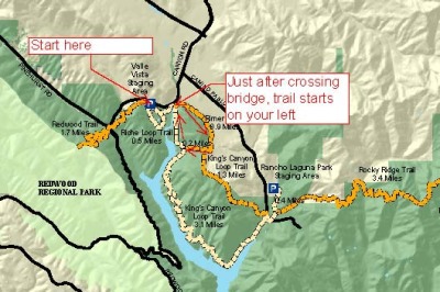
Parts of this trail and King's Canyon Loop help me imagine what the horse and carriage routes might have been like 150 years ago in California. There were probably some great roads with canopies of oak and Bay trees, like you'll find on these trails.
Trails Taken - Starting out at the Valle Vista staging area, head east toward the King's Canyon trail. Initially the path takes you on the Riche trail, but then you'll see a little path that drops down to a little forest of pine trees. Take this, then cross the bridge over Moraga Creek. Just across the bridge, the trail starts on your left. You'll follow Rimer Creek for a while, and the trail has some nice trees and canopies. Eventually, you'll connect with the Rocky Ridge trail. Take a right on the Rocky Ridge trail for a bit of a climb. You'll reach a point where you can either go straight on the Rocky Ridge trail, or take a right (also on the Rocky Ridge trail). Take a right here, and go down hill to the King's Canyon Loop trail. Take a right here, and you'll head back across the bridge and back to the staging area.
Mileage - 3.37 miles
Trailhead - Start at the Valle Vista staging area, toilet here, but no water
Notes and Impressions -
Rimer Creek Trail is one of those easy Sunday morning kind of hikes. It's short enjoyable hike with opportunities to see grazing horses, and numerous water birds and raptors. This trail can get very soggy after rains.
This is one of my favorite running trails, especially if you like 10k's. There are some steep sections, and a wonderful variety of wildlife.
Trails Taken - Starting out at the Valle Vista staging area
Head east, toward the bridge over Moraga Creek. (Left as you face the sign in sheet).
Cross the bridge and continue past the pasture on the left and Reservoir on your right. You'll see some ranch buildings and some portable toilets. Up ahead there is a little bench on your right that looks over the reservoir in a very nice area for birding. If birding is all you want, sit here and enjoy yourself as you watch a huge variety of birds feeding, flying and hunting.
The trail goes to your left a little. You'll reach a cattle gate. To your left is the Rocky Ridge trail, to your right is the King's Canyon trail. Go to your right. Follow this beauty as you hike along the reservoir to your right. The trail is mostly wide, but there are some nice elevation changes. There are some benches along the way, with a real nice one high above the reservoir. Keep going on this trail and follow the reservoir as it narrows to a tributary. Eventually, you'll connect with a path that takes you to the Rancho Laguna park. Instead of going through the gate, take a left and continue on the Rocky Ridge trail. You'll see a narrow road to your right on the other side of the fence. Stay on the narrow Rocky Ridge path, and you'll start some short but serious climbing. This is where I saw a wandering California Newt, so be careful where you step. These are nice little lizards just out looking for some love. Keep on the Rocky Ridge trail, and follow it back down toward the reservoir. Take a right back on to the King's Canyon Loop trail, past the same buildings you saw on your way in. Continue back to the Valle Vista trailhead.
Mileage - 6.1 miles
Trailhead - Valle Vista staging area, toilets, no water
Notes and Impressions - This is a hike that builds appetites. With numerous climbs and descents, you'll be hungry and thirsty at the end of this adventure, even if you've enjoyed snacks and water on the trail.
The Upper San Leandro reservoir is home to a huge variety of birds, so bring your binoculars. There are also numerous canopies on the trail, with some huge oaks and bay trees.
The Rim Trail is a runner's dream, if you're a runner who likes hills. There aren't really switch backs here, you just have to climb. These hills go up and down, and can get a little crazy if there has been rain. You may find yourself sliding down the trail if you're not careful.
Trails Taken - East Bay Mud - Permit Required
Started at the Campolindo Drive trailhead
L up Rim Trail
R on Canyon trail, down to valley
Stay on trail, continues to Rheem Trail (Real nice climb at the end)
End at trailhead
Mileage - 2.3 miles
Trailhead - Where did I start and finish, location of bathrooms, water, etc...
Notes and Impressions -
The Rim Trail (MAP HERE) is a 4.7 mile loop that circles the Lafayette Reservoir. However, there are numerous trails that cross the valley and can give you a shorter but perhaps steeper hike or run. The valley in the spring is a vibrant, almost glowing green. It's what I imagine the hills of Ireland look like. What you'll enjoy about the trail system here is the opportunity to get a great work out. The trails are wide and accessible, but there are some seriously steep climbs as well. You can zip up and down between the outer Rim trail and the trails that connect to the paved trail around the reservoir, or stay on the dirt fire road trail the whole time.
The images here are from several hikes last year. You can take the whole rim trail along the outer edges of the Lafayette Reservoir Recreation area, or hike across the lush valley in the middle. Either way, you're guaranteed some hills and climbing.
The area is loaded with wildlife. You may hear or see wild turkey, deer, loads of jays, and an assortment of other raptor birds.